

Precision agriculture and autonomous machinery depend on one fundamental capability: knowing where a machine is, how it is moving, and how its current position relates to a planned path.
Without dependable spatial information, automated steering and field operations can drift away from their intended routes. That makes global navigation more than a positioning feature; it becomes a reference layer connecting field data, machine control, and autonomous decision-making.
The question of whether a vehicle can find its coordinates is not the only one for system integrators and producers of agricultural equipment. Repeatable movement under varied operational circumstances necessitates constant positioning. For autonomous applications, Archimedes Innovation has developed location, vision, and control solutions that work together to tackle this difficulty.
Precision Machinery Needs a Reliable Spatial Reference
A tractor, sprayer, seeder, or robotic platform operates within a physical environment where small deviations can affect the next movement. Straight-line guidance, repeated passes, row following, and automated turning all require the machine to understand its relationship with a predefined route.
Basic satellite positioning can provide a useful location estimate, but precision operations can demand substantially finer information. Archimedes Innovation notes that standard GNSS positioning at meter-level accuracy may not satisfy precision seeding requirements, while its AS10 agricultural autopilot uses RTK positioning for high-precision guidance.
That distinction explains why positioning solutions are central to autonomous agriculture. Navigation data has to be accurate enough for the intended operation, stable enough for continuous control, and available quickly enough for the vehicle’s guidance system to respond.
Why Ordinary Location Data Is Not Enough?
Coordinates alone do not tell an autonomous machine everything it needs to know. A control system also needs information about movement, direction, timing, and changes in position. Heading becomes particularly important when a machine must maintain a planned trajectory rather than simply reach a destination.
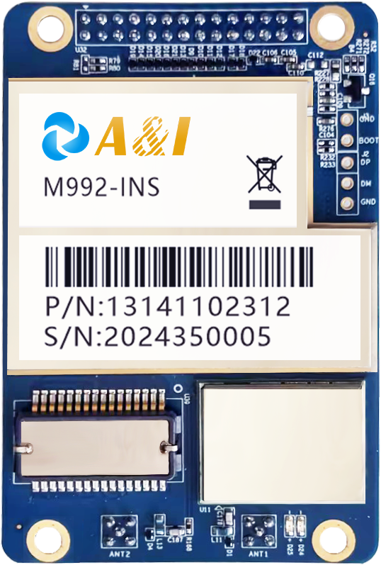
GNSS combined with inertial sensing can provide a more complete navigation picture. The M992-INS, for example, combines dual-antenna GNSS with inertial navigation and supports positioning and orientation outputs at high frequencies. Its design is intended for applications including machine control and autonomous vehicles.
Continuity also matters. Agricultural machinery can encounter foliage, uneven terrain, signal obstruction, or other conditions that complicate satellite reception. A navigation architecture that combines multiple positioning and inertial strategies can therefore be more useful than a system relying on one positioning method alone.
Global Navigation Connects Positioning With Machine Control
The value of global navigation becomes clearer when navigation data is viewed as an input to the complete automation chain. A positioning receiver determines location and movement information; software interprets that information against a planned route; the control system then adjusts steering or vehicle behavior.
This connection is already reflected in agricultural autopilot architectures. AS10 integrates a high-precision positioning module with an intelligent control terminal and electric steering wheel, enabling automated path guidance for tractors, seeders, and crop-protection machinery.
Developers of such equipment would do well to review navigation not as a separate GNSS component but as an integral aspect of the control architecture. The efficiency with which location data is translated into physically moving machines can be affected by factors such as the availability of interfaces, the pace of updates, synchronisation, calibration, and compatibility with vehicle controllers.
Where High-Precision Navigation Changes Agricultural Operations?
Precision seeding provides a clear example. Repeated passes must follow planned lines while minimizing unnecessary overlap and missed areas. Small path errors can accumulate across a large field, making consistent guidance valuable for operational repeatability.
Crop protection presents a different but related requirement. Spraying equipment needs controlled movement across predefined working areas, while harvesting and land preparation also depend on predictable machine trajectories. AS10 is specifically positioned for crop protection spraying, ridging and land preparation, harvesting, and precision seeding.
Here, positioning solutions are not simply responsible for displaying a vehicle on a map. They provide machine-control inputs that can support repeatable paths and automated driving functions.
What Makes a Navigation System Suitable for Autonomy?
A suitable system needs to match the machine’s operating environment and control requirements. Accuracy is one consideration, but it should be assessed alongside heading performance, update frequency, signal resilience, interfaces, and integration with inertial sensors.
The A&I PBOX illustrates this broader approach. Its navigation engine combines PVT, RTK, loose and tight coupling strategies with interference and anomaly detection, while interfaces include CAN, Ethernet, RS232, RS422, and PPS for integration with other vehicle systems.
Environmental design can matter equally for agricultural equipment. Machinery may operate outdoors across demanding temperature, vibration, dust, and moisture conditions. Selecting navigation hardware therefore requires attention to the complete deployment environment rather than headline positioning accuracy alone.
Turning Navigation Data Into Repeatable Machine Behavior
The strongest case for navigation in autonomous machinery is ultimately operational: accurate spatial information allows software and control systems to act on a consistent understanding of the machine’s location and orientation.
Archimedes Innovation develops GNSS and automatic-control technologies as part of its broader positioning and perception offering, reflecting the importance of treating navigation as a foundation for autonomy rather than a standalone sensor function.
System integrators, robotics developers, and agricultural OEMs should choose navigation technology based on the full autonomous workflow. For control, sensing, and automotive electronics to work together smoothly, the correct architecture is essential for delivering the necessary precision and continuity.
That is why navigation matters so strongly in precision agriculture: it turns physical movement into measurable, repeatable, and controllable motion. Once a machine can reliably establish where it is and how it is oriented, automated guidance can operate against a defined spatial reference. The result is a stronger technical foundation for autonomous machinery that must perform consistently across real-world agricultural environments.
